WaterTribeTM Everglades Challenge (EC)
Tampa Bay To Key Largo In Sea Kayaks, Canoes and Small Boats
The next Everglades Challenge is
Saturday, March 13, 2027. There is registration and equipment inspection on Friday, March 12, 2027, prior to starting.
Cost is $495.00
for the captain and $495.00 for
crew members if any.
Billing starts
Friday, January 1, 2027
The Registration and Payment Deadline is
Sunday, January 31, 2027 at noon.
Due to the exteme commitment for this race late registration and/or late payments will not be allowed. We recommend that you commit to this race early so you have plenty of time for planning, training, and preparation. Pay early in the payment cycle. You can get a full refund up
to the Payment Deadline. No refunds after that
date and time.
All WaterTribe events are dangerous events as defined by Florida law and common
sense. You are responsible for your own safety. You must read and
understand the warning before you register for this event.
The Everglades Challenge is an unsupported, expedition style adventure race for
kayaks, canoes, and small boats. The distance is roughly 300 nautical miles depending
on your course selection. There is a time limit of 8 days or less. Your safety and
well being are completely up to you.
Unsupported means that there are no safety boats or support crews to help you during
the race. You are not allowed to have a support crew follow you or meet you during
the race. It is OK to have family or friends meet you at the official checkpoints,
but they cannot provide anything other than emotional support. See the official
WaterTribe rules for more details.
Expedition style means that you must carry the same type of equipment and supplies
that you would carry on a major expedition lasting 4 weeks or more. Camping equipment,
food, water, safety, communication, etc. is required. See the Rules and Warning
link at the top of this page for the official required equipment list for more details.
Although this is a race, many participants are more interesting in cruising and
adventure. Whether you are a cruiser or racer is up to you. Just getting to the
starting line is a major accomplishment and only about 40% of starters are able
to finish. You should be an expert kayaker and/or sailor before
you consider this challenge.
SPECIAL NOTE 1: You can earn an alligator
tooth award by completing the entire Everglades Wilderness Waterway between Chokoloskee
and Flamingo. There are specific rules for earning that tooth:
- You must obey all Everglades National Park rules.
- SPOT/inReach must be correctly used at all times.
- You must complete the entire WW as shown on their official maps. You can exit at
Broad River and return via Broad Creek. Using the Harney River from the outside
is not allowed.
- The Nightmare is an option. Some people say that taking the Nightmare is easier
than negotiating Broad Creek from the entrance. The choice is yours.
- Once you have reached Whitewater Bay you may follow the marked route or take the
Joe River or any other route to cross the bay and enter Tarpon Creek and the Buttonwood
Canal.
- In some years challengers have taken the Hells Bay Canoe Trail to Tarpon Creek.
Since this is marked on the official map, it is also OK.
- You must portage your boat a short distance between the fresh water side and the
salt water side at Flamingo. You cannot receive assistance from the Race Manager,
CP Captain, or bystanders. Challengers participating in the event may assist other
challengers (see the note below).
SPECIAL NOTE 2: In some previous years
we have provided a boat cart or other assistance for the short portage at Flamingo.
As of EC2011 and beyond a boat cart will not be provided and all challengers crossing
from the fresh water side to the salt water side must do this short portage without
outside assistance. No cart will be provided. You must carry your own if you plan
to use one. If bystanders want to help they cannot. However, other WaterTribers
who are in the same event can help - see the ad hoc team rule.
The Everglades Challenge follows the SW Florida coast line from Fort Desoto in Tampa
Bay, Florida to Key Largo. You will enter Everglades National Park near Everglades
City and you will be within their boundries until you get near Key Largo.
You must follow all park rules and regulations.
Note that the WaterTribe Marathon runs concurrently with the Everglades Challenge.
The schedule mentions both races.
|
Schedule
Note that the WaterTribe Ultra Marathon runs concurrently with the Everglades Challenge. The
following schedule mentions both races.
Gear Inspection -
Friday, March 12, 2027
Is Mandatory .
Race -
Saturday, March 13, 2027 to
Sunday, March 21, 2027.
| Locations
|
Deadlines
|
Notes
|
Captains
Meeting
Gear
Inspection
|
Tampa Bay
Fort Desoto
East Beach
Shelter 14
|
Friday
Registration, Gear & Boat Inspection:
09:00-14:30
Captains Meeting 15:00
Off the beach and
out of the park by 17:30 |
Attendance Is Mandatory
Access to Beach has changed:
NO VEHICLE ACCESS TO THE BEACH.
Classes 1, 2, and 3 must be transported to the beach by hand or by using a beach cart.
Classes 4, 5, and 6 must be transported to the beach by hand or by using a beach cart WHEN POSSIBLE.
If not possible,
they can access the beach via water (special rules apply).
There are some special rules defined in the upcoming PDF.
|
| Start:
|
Tampa Bay
Fort Desoto
East Beach
in front of Shelter 14
Or Boat Ramp
|
Saturday
Park Access 07:00
Roll Call 08:00
Launch 08:30 |
Start for Everglades Challenge, Ultra Marathon and Ultimate Florida Challenge
Beach Starters and Boat Ramp starters must attend roll call.
|
Finish:
and
CP1:
|
Cape Haze Marina
Englewood, FL
|
Sunday
Ultra Marathon Award Deadline: 13:30
Challenger Deadline: Noon
|
WaterTribe Ultra Marathon Finish Line. In the UM you should finish by 13:30.
CP1 for Everglades Challengers and Ultimate Florida Challenge. As of EC2026 both UM and EC particiapants must get to CP1 by 13:30 Sunday. |
| CP2:
|
Outdoor Resorts
Chokoloskee, FL
|
Wednesday 10:00
|
EC and UF Challengers Only
|
| CP3:
|
Yacht Basin
Flamingo, FL
|
Friday 10:00
|
EC and UF Challengers Only
|
| Finish:
|
Pelican Cottages
Key Largo, FL
|
Award Ceremony
Saturday 10:30
Award Lunch
Saturday ~ 11:30
Deadline
Sunday 07:00
Departure
Sunday 10:00
|
WaterTribe Everglades Challenge Finish Line
Stage 1 for the Ultimate Florida
|
Start - Fort De Soto Park, Tampa Bay, Florida
There are three events starting at the same time in Fort De Soto Park located on Mullet Key in Tampa Bay, Florida. These events are the Everglades Challenge, the Ultra Marathon, and the Ultimate Florida Challenge. Pavilions
13, 14, and 15 are reserved
for all day Friday. Pavilion 14 will be our main registration and meeting place. We reserve the other two pavilians so that we have full access to the parking lot. Boats may assemble on East Beach facing south adjacent to shelters.
All boats should be left on the beach above the high water mark Friday night.
A guard will be posted.
The Pavilion 14 is at East Beach on the eastern leg of Mullet Key facing south.
There is a very nice beach perfect for launching boats.
This year and going forward, there is no road access to the beach. You must transport your kayak, canoe, or small sailboat by hand from the parking lot to the beach. If you cannot do that, you can sail around and pull your boat up onto the beach, but there are special rules regarding this. These rules will be published soon.
New Launch Procedure
Here's the BLUF:
- No road access to the beach. This applies to all Pinellas County Parks. They are protecting beach grasses and beach plants. WaterTribe fully supports this endeavor.
- All boats in Classes 1, 2, and 3 must be transported from the parking lot to the beach by hand. Boats may be carried or pulled by hand on a portage cart. Balloon tires are
strongly recommended for this job. All other boats in Classes 4, 5, and 6 can use this method when possible.
- Boats in Classes 4, 5, and 6 can access the beach via water if necessary. There are some special rules defined in the upcoming PDF.
Note that this is a work in process and some details could change over the next couple of weeks. The above information will be updated as necessary and a PDF with full details will be published when everything if finalized.
Camping on Mullet Key at Fort De Soto
There is a very nice campground on Mullet Key.
-
Sites 1-85 are designed for tent, van, and pop-up campers.
-
Sites 86-233 are designed and equipped to accommodate all camping units
-
All sites have water, electrical hookup ( 30 amps), picnic table, and a charcoal
grill
-
Dump stations, restrooms, showers, and laundry are available
-
Many sites are waterfront with room for your kayak or boat in your camp site.
Reservation is VERY limited. Reserve your site as early as possible.
Google Fort De Soto park for reservation information.
|
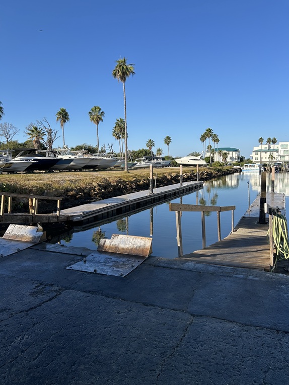
EC CP1 and UM Finish - Cape Haze Marina, Englewood, Florida
Cape Haze Marina is the first checkpoint for the Everglades Challenge and the finish
for the Ultra Marathon.
Roughly 60 miles along the coast from Tampa Bay you will come to Stump Pass which
feeds into the Intracoastal Waterway. The Cape Haze Marina checkpoint is located
a couple miles south of Stump Pass on your port side.
Finding Cape Haze Marina
Near Intracoastal Waterway Markers Red "8" and Green "9" there are
private channel markers into Cape Haze Marina on your port side as you are heading south.
After entering the Marina, turn right just after the first set of docks. Turn left at the
sea wall and proceed to the floating dock next to the rock sea wall. Note: If your
Class 4, 5, or 6 boat is too large or too difficult to get into the Marina, then it is not a
suitable Everglades Challenge boat. Violation of this rule results in a DQ.
- Cape Haze Entrance
Lat 26.875422°
Lon -82.314172°
- Cape Haze Dock
Lat 26.874206°
Lon -82.312763°
- CP1Beach001 - See SMALL BEACH LANDING BELOW
Lat 26.87348°
Lon 82.31439°
- CP1Beach002 - Trail Head to CP1 - See SMALL BEACH LANDING BELOW
Lat 26.87363°
Lon 82.31445°
SMALL BEACH LANDING - The beach landing is for Class 1, Class 2, Class 3, Hobie
AIs, and Hobie TIs only. All other boats must go into the Marina docks. Class 3
boats and Hobies MUST retract or take off their amas and akas. Also, if you will
be at CP1 longer than 30 minutes, you must move your boat up
to the grassy area at CP1. These rules are intentional filters.
The beach landing is located near marker Red 8. As you are heading south, turn left just
after passing Red 8 and you can't miss the beach landing. The landing and trail to CP1
are near an apartment building so BE QUIET when you land or launch.
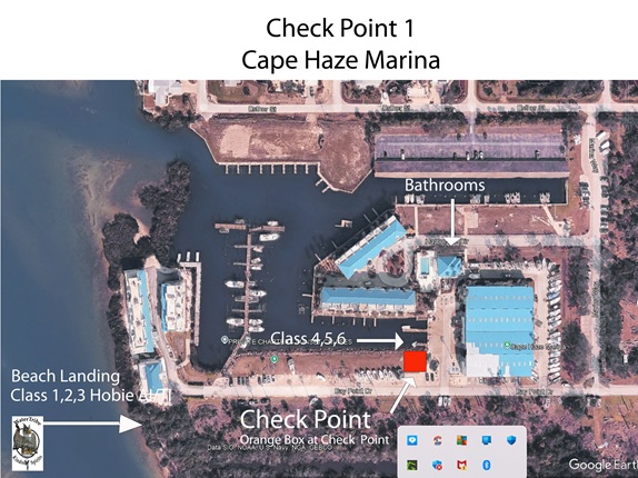
Check-In and Beach Landing
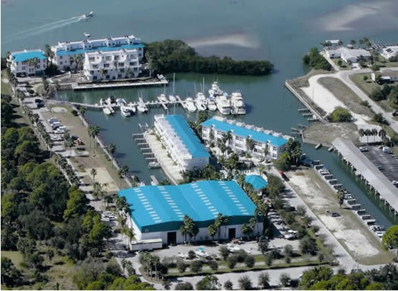
Cape Haze Marina Overview
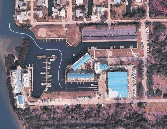
IMPORTANT: Cape Haze Entrance Route
Slips shown in the Overview are GONE for now.
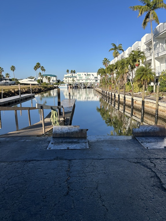
Floating Dock for Check-In
Checkpoint Captains will be set up in the grass area near the Marina docks. The Orange Lock Box containing
the check-in log will be in this area. The lock combination is 3 - 1 – 4. Please be sure the box is relocked
and secure after signing in.
Resupply is available at the Cape Haze Convenience Store, which is located at the end
of the Marina driveway. Their hours are 6am-7pm on Saturdays and 7am-5pm on Sundays.
There are also grocery stores within a couple of miles from the Marina. Fresh hose water
is available at the Marina, but you might want to filter for taste. Bottled water, sodas,
and snacks are available at the bait shop during Marina business hours.
Restrooms are available in the Marina store. See a check-point captain for access afterhours.
Camping is not permitted at CP1 except those finishing the Ultra Marathon or in an
emergency situation.
Vehicle parking is available in the lot behind the dry boat storage building. There
is also trailer parking for a fee. Please contact the Marina to make arrangements for
trailer parking.
|
CP2 - Chokoloskee, Everglades National Park, Florida
Roughly 70 miles along the coast from Cayo Costa you will come to Indian Key Pass.
The mangrove channel that leads to the fabled Everglades City then on to the
checkpoint in Chokoloskee.
Finding CP2 Physical Check In Station
25° 49.08' N or 25.8180°
81° 21.57' W or -81.3595°
CP2 is located at the Outdoor Resorts of America located at the entrance
to Chokoloskee Island. You will land on the beach on the west side of the causeway. The
orange sign-in box will be across the street near the fish cleaning station unless a volunteer
checkpoint captain directs you otherwise.
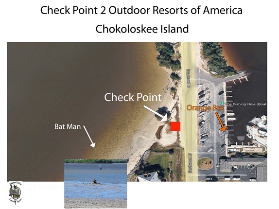
CheckPoint and Batman (avoid)
Checkpoint Captains will be set up on the beach. The Orange Lock Box containing the check-in
log will be across the street in the fish cleaning station. The lock combination is 3 - 1 – 4.
Please be sure the box is relocked and secure after signing in.
The Outdoor Resorts of Chokoloskee offers a small convenience store. Store hours are
6:30am-6:00pm. If you have friends or family meeting you at the CP, motel rooms may be availableby
calling 239-695-2881. Recommend they reserve sooner rather than later.
Tent camping is permitted on the small landing beach, but we recommend camping before or after the CP.
It is a very busy area, but if you need to rest, you may do so.
Indian Key Pass
Indian Key Pass is an entrance to the Ten Thousand Islands that is usable by kayaks, canoes, sailboats
and motorized boats all day long almost every day. There are regularly large, motorized personal and
tour boats that cruise these channels so watch out. Some have been known to run at night with no lights.
If you must travel these channels at night, keep lots of lights going on your boat and keep a strong
spot light handy.
Tide will be a factor. There are strong tidal currents throughout the labyrinth of water and mangroves
that make up the Ten Thousand Islands. A huge amount of water flows through these channels, so current
can be 2 to 3 knots or so. Expect as water levels drop or rise various sand/mud/oyster bars are exposed
or covered.
If you use Indian Key Pass to enter Everglades City and Chokoloskee and then use Chokoloskee Pass to exit,
you will minimize tide issues and the need for local knowledge. These two channels are wide enough and
well marked so as to be considered "normal" navigation and difficulty.
Everglades National Park - Plan Ahead
When you reach Everglades City, you are about to enter the Everglades National Park.You must follow all
park rules and regulations.
NOTE: You must get your permit online before you enter the park. If you haven't done this already,
do it now. Camping permits must also be obtained online. Here is a list:
If you don't get a camping permit, you are not supposed to camp. However, there is no rule that
I know of that prevents you from stopping for a snack or a break. DO NOT camp without a permit.
Remember to practice the LEAVE NO TRACE principles during this race and especially while in the park.
The Everglades National Park is a unique treasure that we must help preserve.
|
CP3 - Flamingo, Everglades National Park, Florida
Roughly 60 miles along the coast from Indian Key Pass you will come to Cape Sable. A few miles
around the point and you will find Flamingo. This is the Southernmost headquarters in the
Everglades National Park.
Finding CP3 Physical Check In Station
25° 8.54' N or 25.1423°
80° 55.41' W or -80.9235°
Physical Check In Station
Checkpoint Captains will be set up near the store and will be watching for you. The Orange Lock Box,
containing the check-in log, will be on the bench at the saltwater boat launch unless the CP
volunteers direct you otherwise. The lock combination is 3 - 1 – 4. Please be sure the box is
relocked and secure after signing in.
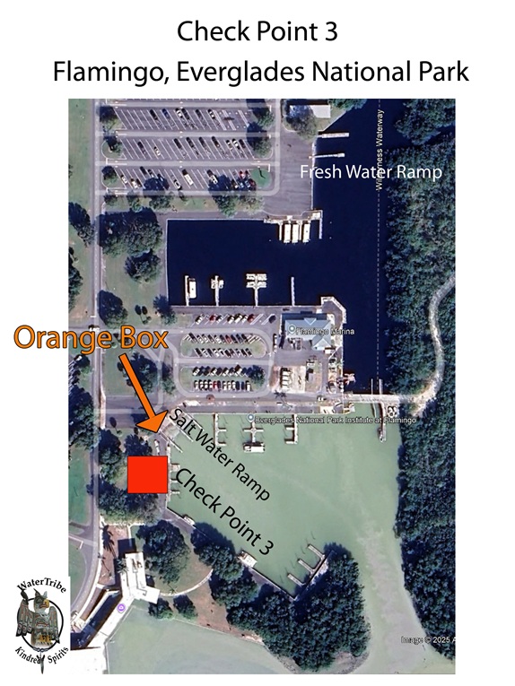
Check-In and Fresh Water Ramp
Amenities at Flamingo
- A well-stocked convenience store is open daily from 7:00am-7:00pm
- Showers are available during store hours for $5.35 (including tax). Payment is made in the store.
- A food truck is projected to be operational in January 2026. Information will be posted when known.
- Flamingo restaurant has breakfast from 7am-10am and lunch/dinner from 11am-9pm.
- Challengers may lie down next to their boats in the grassy areas only. No tents, bivy sacks or hammocks may be deployed.
- Mooring a boat for longer than four hours will require payment of an overnight fee of $2 per foot.
- WiFi is available in the marina and at the lodge.
- 24 hour restrooms are available at the NPS visitor center, the fish cleaning station next to the backcountry boat ramps,
and the campground bathhouses. The restrooms at the store are open from 7AM – 7PM
Tide Is Still a Factor
Tide is always a factor in a small boat. The tide can be even more difficult here
because there are so many factors that enter into it. Fresh water flow from the
glades, Atlantic flow, Gulf flow, wind, pressure, channels. The area is very shallow.
You really must get chart 33E.
Big Boats Are Everywhere
Even bigger boats are cruising these waters so watch out. Some of them run at night
with no lights. If you must travel at night, keep lots of lights going on your boat
and keep a strong spot light handy.
If You Drop Out Here
Since Flamingo is more off the beaten path from the other checkpoints, it is advised
to have had a discussion with your shore contact about what the plan will be to pick
you up if you need to drop out there. Also, please keep checkpoint captain volunteers
updated so they know you are safe and can note the website that you have left the Challenge.
Access for Family and Friends
Flamingo is located on the southern tip of the Florida mainland with highway and good road access.
The entry fee is $30 per vehicle. Eco-tents as well as tent and RV camp sites are available
by reservation. Please use the following link for availability and pricing:
Flamingo Adventures
There is a great 90 minute boat tour up Buttonwood Canal through Coot Bay and Tarpon Creek into Whitewater Bay
narrated by experienced naturalist. Great hiking options in the area as well.
|
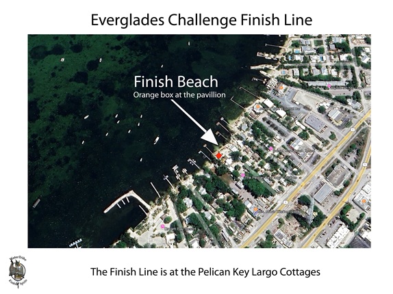
Finish - The Pelican Key Largo Cottages, Key Largo, Florida
The Everglades Challenge finish is at The Pelican Key Largo Cottages.
Lat/Lon of The Pelican Key Largo Cottages
Landing Beach and Dock
025° 05.585 N
080° 26.671 W
|
The Orange Lock Box containing the check-in log will be on the picnic table under the beach palapa.
The lock combination is 3 - 1 – 4. Please be sure the box is relocked and secure after signing in.
New in 2026: Those needing dock space may tie up at the dock on the southside of the property in front
of the beach palapa. Please arrange to trailer your boat as soon as possible to make room for others.
Boats may be brought to the beach only when preparing to remove the vessel from the water. The northside
docks near the ramp are exclusively for those with a reservation at The Pelican. Those using the ramp who
have reservations at The Pelican may keep their vehicle and trailer on property during their stay.
Others need to park elsewhere after loading their vessel. There is some room along Hwy 1 to park temporarily
and there are several marinas in the area to accommodate.
The downstairs of the blue house is available for restrooms, showers, kitchen use and rest. If you need a
place to sleep until the local accommodations you’ve arranged for are ready, you may find a claim a spot.
Thank you for keeping the space clean.
The award ceremony will begin on Saturday at 10:30 AM on the beach. Bring a chair. Immediately following the
award ceremony, please join us for a BBQ luncheon in the large palapa on the north side of the property.
Please sign up for the luncheon when you pick up your t-shirt on check-in day prior to the start.
You may reserve a room or cottage at The Pelican by calling 305-451-3576. Here is a
link: The Pelican Cottages Rooms are limited so reserve early.
It's the place to be! There are other properties available nearby as well
as many Airbnb and VRBO options.
CP volunteers will be onsite to answer questions.
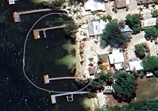
Overview of finish beach. The north dock toward the top and the south dock toward the bottom.
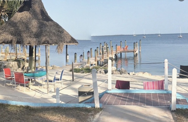
Looking out from the finish beach showing the south dock and the beach palapa.
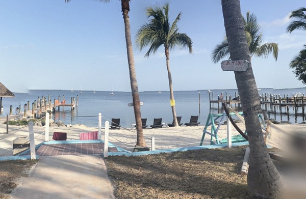
Looking out from the finish beach showing both north and south docks.
|
|
ALL Events - Must Read, Understand, and Agree:
Warning
Rules
Special Launch Rules
Boat Classes
Reefing Rules
Required Equipment
SPOT Setup and Usage
inReach Setup
WaterTribe Entrance Requirements
WaterTribe Skill Assessments
How to Setup A Lifejacket
Packing Lite
Packing for Seaworthiness
|