WaterTribeTM Ultimate Florida Challenge (UF)
Circumnavigating Florida In Sea Kayaks,
Canoes and Small Boats
The next Ultimate Florida Challenge is
Saturday, March 4, 2028. There is registration and equipment
inspection on, Friday, March 3, 2028, prior to starting.
Cost is $1,495.00
for the captain and $995.00 for
crew members if any.
Billing starts Saturday, January 1, 2028
The Registration and Payment Deadline is Monday, January 31, 2028 at noon.
Finishing an Ultimate Florida Challenge will qualify you for a 25% discount on all future WaterTribe events. Cummulative discounts are limited to 50%.
The normal entrance requirements apply to this event. You no longer will be required to complete a previous WaterTribe event to
enter this event. After due consideration it has been decided that the Everglades Challenge for the first stage of this event
is a built in qualifier. That being said, think long and hard about entering the Ultimate Florida Challenge. It is a long, grueling
event that will chew you up and spit you out.
Due to the exteme commitment for this challenge late registration and/or late payments will not be allowed. We recommend that you commit to this race early so you have plenty of time for planning, training, and preparation. Pay early in the payment cycle. You can get a full refund up until January 26 at noon. No refunds after that
date and time.
This is the toughest small boat challenge you will find anywhere. If you want to
test yourself against everything Mother Nature has to throw at you and see what
you are really made of you have found the way.
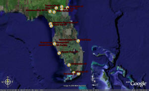
This race circumnavigates Florida in five stages. The checkpoints are shown above.
The first stage starts at Fort Desoto in Tampa Bay, Florida along with the Annual
Everglades Challenge. At Key Largo you turn north and head for the Sebastian Inlet
Stage Point. From there you make your way to the Stage Point at the boat ramp near
Fort Clinch. Then it's about 90 miles upstream on the St. Marys River passing the
virtual CP at Traders Hill and on to the virtual CP at St. George. Here you will
begin the infamous 40-mile portage to the Suwannee River at the Fargo virtual CP.
After about 220 miles down river you are back in the Gulf of Mexico - next stop
the Cedar Key Stage Point. The final sprint from Cedar Key finishes back at Fort
Desoto. It's hard to predict which stage will be the toughest since weather will
be a factor, but watch out for the 40-mile portage between the St. Marys River and
the Suwannee River - it's a heart breaker - or maybe a feet shredder.
Resupply and Support
Each major Stage Point (Key Largo, Sebastian Inlet, Fort Clinch, and Cedar Key)
is treated like the end point of a WaterTribe Challenge. That means you can have
whatever support you want at these points. Virtual checkpoints like Traders Hill,
St. George, Fargo, after Big Shoals, and Suwannee River State Park are treated like
Everglades Challenge CPs and Rule 4 covers these locations.
Note that race officials may or may not be present at these Stage Points and virtual
checkpoints. It depends on many factors including how many challengers are in the
event, how spread out those challengers are, and how many race officials are available.
What is a virtual checkpoint? You are required to send an OK or Custom Message at
virtual checkpoints.
Duration and Awards
Although the deadlines allow just a bit more than 29 days to complete the Ultimate
Florida Challenge, hard chargers might be able to do this in 15 days or so, but
the weather would have to cooperate. A more reasonable target is 20 days give a
take a couple of days. Cruisers may take a more leisurely pace and use every minute
of the allowed time. Of course, this challenge is so tough that it is possible that
nobody can complete it in the allowed time limits - we'll see.
Finishing Stage 1 (EC) earns a shark tooth and an alligator tooth if you take the
full Everglades WW.
Finishing Stage 2 earns a shark tooth.
Finishing stage 3 earns a shark tooth.
Finishing stage 4 earns an alligator tooth.
Finishing stage 5 earns a whale tail.
You must do the whole Ultimage Florida Challenge. Individual stages cannot be entered
seperately except for the Everglades Challenge.
Note that missing deadlines (grace periods), clearance to leave, and other rules
are covered in detail in other pages of this web site.
Important Note: SPOT with tracking feature is
required and correct usage guidelines must be followed.
If you don't want to buy a SPOT, you can rent one here:
TrackMe360
Schedule
Note that the WaterTribe Ultimate Florida Challenge runs concurrently with the Everglades
Challenge. You should examine the Everglades Challenge information carefully.
Gear Inspection -
Friday, March 3, 2028
Is Mandatory .
Race -
Saturday, March 4, 2028 to
Friday, March 31, 2028.
The following table shows the schedule for the first stage. This includes inspections,
captains meeting, the start and checkpoints that are in common with the Everglades
Challenge.
|
Locations
|
Deadlines
|
Notes
|
Gear
Inspection
Captains
Meeting
|
Tampa Bay
Fort Desoto
East Beach
Shelter 14
|
Friday
Registration, Gear & Boat Inspection:
08:00-14:30
Captains Meeting 15:00
Off the beach and
out of the park: 18:00 |
Attendance Is Mandatory
|
|
Start
|
Tampa Bay
Fort Desoto
East Beach
in front of Shelter 14
|
Saturday
Park Access 07:00
Launch 08:30 |
Start for Everglades Challenge, Ultra Marathon and Ultimate Florida Challenge -Classes 1, 2, and 3 plus any boat that can be transported from the parking lot to the beach. NO VEHICLE ACCESS TO THE BEACH.
All other classes and boats that cannot be transported from the parking lot to the beach will launch from the boat ramp. |
|
CP1
|
Cape Haze Marina
Englewood, FL
|
Sunday
Ultra Marathon
Award Deadline: Noon
Challenger Deadline: Noon
|
WaterTribe Ultra Marathon Finish Line. In the UM you should finish by noon.
CP1 for Everglades Challengers and Ultimate Florida Challenge.
As of EC2008 UM, EC, and UF particiapants must get to CP1 by noon Sunday. |
|
CP2
|
Outdoor Resorts
Chokoloskee, FL
|
Wednesday 10:00
|
EC and UF Challengers Only
|
|
CP3
|
Yacht Basin
Flamingo, FL
|
Friday 10:00
|
EC and UF Challengers Only
|
|
Finish
|
Pelican Cottages
Key Largo, FL
|
Award Ceremony
Saturday 09:00
Award Brunch
Saturday ~ 10:00
Deadline
Sunday 07:00
Departure
Sunday 10:00
|
WaterTribe Everglades Challenge Finish Line
AND End of Stage 1 for Ultimate Florida Challenge
|
The next table shows the schedule for each stage.
Note that the deadlines shown here apply to the Ultimate Challenge. The regular
Everglades Challenge participants will have until Sunday at noon to finish.
|
Stage
|
Start
|
Deadline
|
Days
|
|
1
|
Shark and Alligator Tooth Challenge
Fort Desoto to Key Largo
Everglades Challenge Course
|
Saturday
3/4/2028
8:30 AM
|
Thursday
3/9/2028
7:00 AM
|
4
|
|
2
|
Shark Tooth Challenge
Key Largo to Sebastian Inlet State Park |
Thursday
3/9/2028
7:00 AM
|
Thursday
3/16/2028
7:00 AM
|
7
|
|
3
|
Shark Tooth Challenge
Sebastian Inlet State Park to Fort Clinch State Park |
Thursday
3/16/2028
7:00 AM
|
Thursday
3/23/2028
7:00 AM
|
7
|
|
4
|
Alligator Tooth Challenge
Fort Clinch State Park to Cedar Key |
Thursday
3/23/2028
7:00 AM
|
Tuesday
3/28/2028
7:00 AM
|
5
|
|
5
|
Whale Tail Sprint
Cedar Key to Fort Desoto
|
Tuesday
3/28/2028
7:00 AM
|
Friday
3/31/2028
12:00 PM
|
3
|
Start - Fort De Soto Park, Tampa Bay, Florida
There are three events starting at the same time in Fort De Soto Park located on Mullet Key in Tampa Bay, Florida. These events are the Everglades Challenge, the Ultra Marathon, and the Ultimate Florida Challenge. Pavilions
13, 14, and 15 are reserved
for all day Friday. Pavilion 14 will be our main registration and meeting place. We reserve the other two pavilians so that we have full access to the parking lot. Boats may assemble on East Beach facing south adjacent to shelters.
All boats should be left on the beach above the high water mark Friday night.
A guard will be posted.
The Pavilion 14 is at East Beach on the eastern leg of Mullet Key facing south.
There is a very nice beach perfect for launching boats.
This year and going forward, there is no road access to the beach. You must transport your kayak, canoe, or small sailboat by hand from the parking lot to the beach. If you cannot do that, you can sail around and pull your boat up onto the beach, but there are special rules regarding this. These rules will be published soon.
New Launch Procedure
Here's the BLUF:
- No road access to the beach. This applies to all Pinellas County Parks. They are protecting beach grasses and beach plants. WaterTribe fully supports this endeavor.
- All boats in Classes 1, 2, and 3 must be transported from the parking lot to the beach by hand. Boats may be carried or pulled by hand on a portage cart. Balloon tires are
strongly recommended for this job. All other boats in Classes 4, 5, and 6 can use this method when possible.
- Boats in Classes 4, 5, and 6 can access the beach via water if necessary. There are some special rules defined in the upcoming PDF.
Note that this is a work in process and some details could change over the next couple of weeks. The above information will be updated as necessary and a PDF with full details will be published when everything if finalized.
Camping on Mullet Key at Fort De Soto
There is a very nice campground on Mullet Key.
-
Sites 1-85 are designed for tent, van, and pop-up campers.
-
Sites 86-233 are designed and equipped to accommodate all camping units
-
All sites have water, electrical hookup ( 30 amps), picnic table, and a charcoal
grill
-
Dump stations, restrooms, showers, and laundry are available
-
Many sites are waterfront with room for your kayak or boat in your camp site.
Reservation is VERY limited. Reserve your site as early as possible.
Google Fort De Soto park for reservation information.
|
Fort Desoto to Key Largo
Same as Everglades Challenge
This is Stage 1 for the Ultimate Florida Challenge and Stage 3 for the Florida Coastal Challenge. It is almost identical to the
Everglades Challenge. The only difference is that the deadline for Key Largo is about one day sooner than the
Everglades Challenge deadline.
Yes, you do have to go into all EC checkpoints and hit your OK or Custom button. There will be logbooks to sign in too.
Rather than repeat all the EC info here, just go to the Everglades Challenge
section, but note the different deadline for Key Largo.
Key Largo to Sebastian Inlet
Hopefully you saved some energy during the Everglades Challenge section because now it is
time to turn north and make your way from Key Largo to Sebastian Inlet State Park.
Although there are some "wild" areas in this stage, it is also one of the most populated
areas in Florida with more than its share of boat traffic. Be careful and stay alert.
This stage is roughly 180 nautical miles. Since you have proven yourself by finishing
the Everglades Challenge and we want to keep the Ultimate Florida Challenge a true
expedition-style adventure, there are no checkpoints between Key Largo and Sebastian
Inlet. This lack of checkpoints means that correct usage of your SPOT is even more
important. Fortunately, cell phone coverage is good over most of this stage.
A race official may or may not meet you at the Stage Point and provide help with resupply
if you need it.
A race official may or may not supply a ride to local stores for resupply, maintenance
of equipment, laundry, etc. Please note that it could take a few hours for someone
to meet with you since we may be spread out over distances of a couple of hundred
miles.
A camp site may or may not be available, but there are plenty of places for a stealth camp.
Sebastian Inlet to Fort Clinch - Official Finish of Florida Coastal Challenge
Ready for some more? Just keep heading north and after about 170 nautical miles
you'll run into Fort Clinch just before you cross into Georgia. You will paddle
thru heavily populated areas and some really nice areas.
Again during this stage there are no checkpoints between Sebastian Inlet and Fort
Clinch. You are on your own but you must keep reporting your progress at least once
in each 24 hour period and your SPOT must stay on.
The location of the landing for this SP is just on the north side of the public boat landing.
A camp site in the park may or may not be available for your use. Fort Clinch is not kayak
friendly at this time so we will figure something out. There is good bivvy camping next
to the sandy beach landing spot on the north side. Be careful not to cross into the park if bivvy camping.
A race official may or may not provide a ride to local stores for re supply, maintenance
of equipment, laundry, etc. Please note that it could take a few hours for someone
to meet with you since we may be spread out over distances of a couple of hundred
miles.
It could take several hours for a race official to meet with you at or near Fort
Clinch because challengers may be spread out by several hundred miles. Use your
SPOT to check in via an OK Message. If you need a ride or help for resupply, call
the race manager or CP Captain or the Roving Captain.
Fort Clinch to Cedar Key
This just might be the toughest stage of the whole challenge. Certainly it is the
longest consisting of 90 miles upstream on the St. Marys River, a 40-mile portage
from St. George to Fargo, 220 miles downstream on the Suwannee River, and a final
20 miles to Cedar Key for a grand total of over 370 miles. Several miles on the
rivers can be extremely difficult depending on water levels any given year. If the
water is too low, you end up pushing and pulling your boat for mile after mile.
If the water is too high, first you are fighting a strong current on the St. Marys.
Then you are dealing with white water at Big Shoals and other spots in a loaded
boat designed for straight line cruising.
But there is some good news. The upper St. Marys and Suwannee Rivers have some of
the most interesting and beautiful campsites you will find anywhere.
Did I mention alligators? Cottonmouths? Rattlers? Pray for cold weather so these
critters are slower than normal.
So are you ready for some fun!
This stage does have some checkpoints along the way:
- Stage 4, CP1 - Traders Hill on the St. Marys River, Georgia side
- Stage 4, CP2 - St. George on the St. Marys River, Georga side
- Stage 4, CP3 - The landing on the Suwannee River at the town of Fargo, GA
These checkpoints will NOT have a lock box at the location due to theft during previous
challenges. Instead, your SPOT OK Message sent from these locations will confirm
arrival. In many cases race officials will be at these checkpoints when you get
there, but that is not always going to be true.
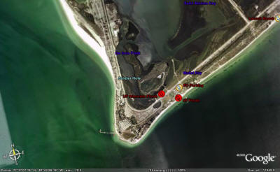
Fort Clinch
Fort Clinch State Park is located at the very NE tip of Florida near Fernandina
Beach which is north of Jacksonville.
New Option: Any Class may switch to any other Class
at Fort Clinch. You can also switch at the town of St. Marys but you must inform
a race official of your plans.
- You must have your shore crew meet you at Fort Clinch or St. Marys to make the switch. They will
meet you again at Cedar Key or the town of Suwannee to switch back to your original boat.
- You must carry all gear that you need for stage 4 for the entire challenge. The
only thing that can be switched is the boat and paddles. Everything needed for the
stage 4 boat must be carried the entire race. All of this will be checked at inspection.
- Boat switchers are not allowed to use a bike for the portage. You must walk.
- Class 4 and 5 challengers that do not switch boats will get a special designator
in the race results.
- If you are planning to switch boats, you must describe both boats in the boat description
section of your registration. For example, beach cat switching to Seda kayak for
stage 4.
- Note the Hobie AIs and TIs may remove all aka, ama, and sail parts instead of switching
boats. Then the boat description might say, Hobie AI stripping down for stage 4.
- Note that you must switch to a Class 1 boat which means you can still have a downwind
sail up to 1 square meter per paddler, but this sail must be carried the whole race.
- A race official MUST be informed and OK the switch BEFORE it can take place.
You may have to wait several hours for the official to approve the switch. DO NOT MOVE ANYTHING
until the race official is there. Instead of getting mad about any delay that might
occur, take the time to rest, eat, and recover.
St. Marys River to Traders Hill and St. George
Here is a pdf showing the river route from Fort Clinch to Traders Hill and St. George.
Fort Clinch to St. George
You must paddle upstream from Traders Hill to St. George.
You started in Florida but the first checkpoint for this stage is on the Georgia
side of the river. Traders Hill is a historical site that has been used by the Indians,
the Spanish, the English, and American Colonials. Even Daniel Boone used this site
on some of his southern hunting expeditions. Sailors came up this far to get fresh
water that was known to stay "fresh" for long periods. Known in the 1700 as Fort
Alert, early settlers used the fort as a refuge during the Indian Wars.
Its location at the head of navigation on the St. Marys River made it one of the
most important trading centers in the Southeast. In 1854 it became the county seat
of Charlton County, and maintained that distinction until 1901 when Folkston, flourishing
along the old S.F.W. Railroad from Savannah to Jacksonville, became the new county
seat. Traders Hill Park has been developed at the site of the old courthouse.
It continues today as a popular recreation site with a nice boat ramp and a small
campground.
There are several miles left to go on the St. Marys before you reach St. George
and the take out for the portage to Fargo.
Lat/Lon of Traders Hill Landing is 30.782833° and -082.024167°. This
is the canoe landing on the St. Marys river at the Traders Hill checkpoint. IMPORTANT:
Go past the dock and the cement boat ramp. Go just past a cypress tree/stump. You
will find this nice landing. You can't see this until you pass the cypress tree/stump.
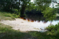
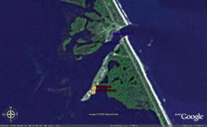
St. George to Fargo
Finally you get to the 40-mile portage route. Here is a pdf showing the portage.
The Portage
Fargo is five miles north of the Florida/Georgia line. After you finish your long
trek from St. George your access point is on the NW side of the river just off of
GA Highway 94. There is a paved launch ramp and a sandy area to camp, but camping
NOT allowed right at the ramp or near the park office.
Fargo is a small town with a good size convenience store (hours are roughly 6 to
11 most days.) and a couple of country restaurants. It is perhaps 1/2 mile from
the canoe landing. Although camping at the landing is not officially allowed, if
you arrive late at night and apply a bit of stealth, you can probably take a break.
If you walk up to the store for re-supply, be sure to take all valuables with you
and leave your boat hidden. Don't be gone too long. It is best to help keep honest
people honest.
Lat/Lon of Fargo Landing is 30.683° and -82.5595°.
Two Important Assets for the Portage
K&C's Oak Tree Cafe in St. George
- The owner's WaterTribe Name is BigOakTree
- One block north of the intersection as you portage through St. George.
- Has a very nice room with bunk beds for rent, shower, bath room, and breakfast
available in the morning
- Serves great food
- 13149 Florida Ave, St George, GA 31562
-
(912) 843-2319
- BigOakTrees cell number will by found on the important numbers sheet
Gator Motel in Fargo
- In town across the street from the convenience store and gas station
- Very nice clean rooms, two double beds, shower, bathroom, microwave, refrigerater,
satellite TV
- 687 US Hwy 441, Fargo, GA 31631
- Owner's cell 229-251-0274
- Web site
Gator Motel
- Call to make a reservation when you are within range and your name will be on
the door when you arrive.
- Nice cafe just up the street. Hours 6 AM to 8 PM everyday except closed on
Sundays
Fargo to White Springs
The Suwannee River has the only class 3 rapids in Florida called the Big Shoals.
Clyde C. Council in his book, Suwannee Country says,
"I do not recommend that you shoot the rapids with a loaded canoe. Unload and with
a Life Preserver try your luck if it looks safe. Shoot the right side of the rapids.
Don't use a fiberglass canoe. I found half of one down river from the rapids one
day."
There is a portage around these rapids. Also, if the water is low you can line your
canoe along the left bank. If you decide to run it, you should scout first and watch
for trees and roots that can snag your boat or you and create very dangerous situations.
The general layout of Big Shoals from upstream to downstream is as follows:
- White warning sign
- Portage takeout on the left bank
- Upstream riffle
- 1st drop
- 2nd drop
- Downstream riffle
- Portage put in
What's a riffle? It's a term for ruffled water due to fast current over rocks but
no real standing waves. Kind of a warning of what is to come. If the water level
is higher, you might not see these riffles.
Note this could have changed since it was last scouted a few years ago.
White Springs is a great place to resupply and maybe get a nice meal. This is a
call in checkpoint. You must call in a report from White Springs.
White Springs to Suwannee River State Park
The Suwannee River State Park marks a transition for the river. The upper Suwannee
is fairly remote. From here to the mouth there is more boat traffic so be careful.
Numerous springs and some great scenery sprinkled between housing development make
up for the increased population and boat traffic. You have another 130 miles to
the Gulf.
The Lat/Lon of Suwannee River State park Boat Ramp Landing is 30.387667°
and 23.26° and -83.169000°.
Suwannee River State Park to Cedar Key
Cedar Key is roughly 20 miles south of the mouth of the Suwannee River on Florida's
west coast.
(NOTE: This is the new location as of the UF2010.)
The finish line will be at the Faraway Inn on the beach at the corner of 3rd and
G streets in Cedar Key. There is a gazebo immediately in front of the beach that
will have the lockbox. This location is much simpler to find and reach especially
during low tide than the old location.
This is a very nice motel and you might want to call ahead to get a room once your
ETA is known.
The Lat/Lon of the Beach at the Cedar Key CP is 29.136° and 83.036°.
If you switched boats at Fort Clinch or St. Marys, you must switch back to your original boat
at or between this SP and the town of Suwannee.
You are almost done with the Toughest Small Boat Race in the World. On to the finish!
Cedar Key to Fort Desoto
You made it to the final leg of a very difficult race. I hope you saved just a bit
of energy because you'll need it. This is the shortest stage of the race, but it's
a sprint --- GO, GO, GO!
You might want to consider the tide when deciding what time to start your sprint.
This is a very exposed coast so be sure to keep a careful eye for storms and currents.
When you get closer to Pinellas County the boat traffic will increase significantly.
Be careful. Unless the weather is bad, it might be best to stay outside for as long
as possible. The inside route through Pinellas is constricted and very busy. If
the weather is bad you might not have a choice, but then the boat traffic will probably
be less too.
You are almost done with the Toughest Small Boat Race in the World. On to the finish!
The finish is jsut after the boat ramp at Fort Desoto next to the bridge. An
exact lat/lon will be provided soon.
Finish Line at Fort Desoto
The finish location is changing due to changes in park rules. Details will be
provided soon.
|
ALL Events - Must Read, Understand, and Agree:
Warning
Rules
Special Launch Rules
Boat Classes
Reefing Rules
Required Equipment
SPOT Setup and Usage
inReach Setup
WaterTribe Entrance Requirements
WaterTribe Skill Assessments
How to Setup A Lifejacket
Packing Lite
Packing for Seaworthiness
|